


NASA, French SWOT Satellite Offers Big View of Small Ocean Features
The international mission collects two-dimensional views of smaller waves and currents that are bringing into focus the ocean’s role in supporting life on Earth. Small things matter, at least when it comes to ocean features like waves and eddies. A recent NASA-led analysis using data from the SWOT (Surface Water and Ocean Topography) satellite found […]
6 min read
Preparations for Next Moonwalk Simulations Underway (and Underwater)
The international mission collects two-dimensional views of smaller waves and currents that are bringing into focus the ocean’s role in supporting life on Earth.
Small things matter, at least when it comes to ocean features like waves and eddies. A recent NASA-led analysis using data from the SWOT (Surface Water and Ocean Topography) satellite found that ocean features as small as a mile across potentially have a larger impact on the movement of nutrients and heat in marine ecosystems than previously thought.
Too small to see well with previous satellites but too large to see in their entirety with ship-based instruments, these relatively small ocean features fall into a category known as the submesoscale. The SWOT satellite, a joint effort between NASA and the French space agency CNES (Centre National d’Études Spatiales), can observe these features and is demonstrating just how important they are, driving much of the vertical transport of things like nutrients, carbon, energy, and heat within the ocean. They also influence the exchange of gases and energy between the ocean and atmosphere.
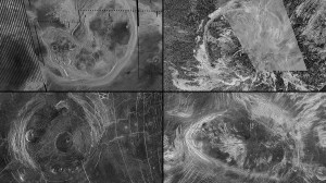
“The role that submesoscale features play in ocean dynamics is what makes them important,” said Matthew Archer, an oceanographer at NASA’s Jet Propulsion Laboratory in Southern California. Some of these features are called out in the animation below, which was created using SWOT sea surface height data.
NASA’s Scientific Visualization Studio
“Vertical currents move heat between the atmosphere and ocean, and in submesoscale eddies, can actually bring up heat from the deep ocean to the surface, warming the atmosphere,” added Archer, who is a coauthor on the submesoscale analysis published in April in the journal Nature. Vertical circulation can also bring up nutrients from the deep sea, supplying marine food webs in surface waters like a steady stream of food trucks supplying festivalgoers.
“Not only can we see the surface of the ocean at 10 times the resolution of before, we can also infer how water and materials are moving at depth,” said Nadya Vinogradova Shiffer, SWOT program scientist at NASA Headquarters in Washington.
Fundamental Force
Researchers have known about these smaller eddies, or circular currents, and waves for decades. From space, Apollo astronauts first spotted sunlight glinting off small-scale eddies about 50 years ago. And through the years, satellites have captured images of submesoscale ocean features, providing limited information such as their presence and size. Ship-based sensors or instruments dropped into the ocean have yielded a more detailed view of submesoscale features, but only for relatively small areas of the ocean and for short periods of time.
The SWOT satellite measures the height of water on nearly all of Earth’s surface, including the ocean and freshwater bodies, at least once every 21 days. The satellite gives researchers a multidimensional view of water levels, which they can use to calculate, for instance, the slope of a wave or eddy. This in turn yields information on the amount of pressure, or force, being applied to the water in the feature. From there, researchers can figure out how fast a current is moving, what’s driving it and —combined with other types of information — how much energy, heat, or nutrients those currents are transporting.
“Force is the fundamental quantity driving fluid motion,” said study coauthor Jinbo Wang, an oceanographer at Texas A&M University in College Station. Once that quantity is known, a researcher can better understand how the ocean interacts with the atmosphere, as well as how changes in one affect the other.
Prime Numbers
Not only was SWOT able to spot a submesoscale eddy in an offshoot of the Kuroshio Current — a major current in the western Pacific Ocean that flows past the southeast coast of Japan — but researchers were also able to estimate the speed of the vertical circulation within that eddy. When SWOT observed the feature, the vertical circulation was likely 20 to 45 feet (6 to 14 meters) per day.
This is a comparatively small amount for vertical transport. However, the ability to make those calculations for eddies around the world, made possible by SWOT, will improve researchers’ understanding of how much energy, heat, and nutrients move between surface waters and the deep sea.
Researchers can do similar calculations for such submesoscale features as an internal solitary wave — a wave driven by forces like the tide sloshing over an underwater plateau. The SWOT satellite spotted an internal wave in the Andaman Sea, located in the northeastern part of the Indian Ocean off Myanmar. Archer and colleagues calculated that the energy contained in that solitary wave was at least twice the amount of energy in a typical internal tide in that region.
This kind of information from SWOT helps researchers refine their models of ocean circulation. A lot of ocean models were trained to show large features, like eddies hundreds of miles across, said Lee Fu, SWOT project scientist at JPL and a study coauthor. “Now they have to learn to model these smaller scale features. That’s what SWOT data is helping with.”
Researchers have already started to incorporate SWOT ocean data into some models, including NASA’s ECCO (Estimating the Circulation and Climate of the Ocean). It may take some time until SWOT data is fully a part of models like ECCO. But once it is, the information will help researchers better understand how the ocean ecosystem will react to a changing world.
More About SWOT
The SWOT satellite was jointly developed by NASA and CNES, with contributions from the Canadian Space Agency (CSA) and the UK Space Agency. Managed for NASA by Caltech in Pasadena, California, JPL leads the U.S. component of the project. For the flight system payload, NASA provided the Ka-band radar interferometer (KaRIn) instrument, a GPS science receiver, a laser retroreflector, a two-beam microwave radiometer, and NASA instrument operations. The Doppler Orbitography and Radioposition Integrated by Satellite system, the dual frequency Poseidon altimeter (developed by Thales Alenia Space), the KaRIn radio-frequency subsystem (together with Thales Alenia Space and with support from the UK Space Agency), the satellite platform, and ground operations were provided by CNES. The KaRIn high-power transmitter assembly was provided by CSA.
To learn more about SWOT, visit:
News Media Contacts
Jane J. Lee / Andrew Wang
Jet Propulsion Laboratory, Pasadena, Calif.
626-491-1943 / 626-379-6874
jane.j.lee@jpl.nasa.gov / andrew.wang@jpl.nasa.gov
2025-070
Share
Details
Related Terms
Explore More


What's Your Reaction?