


NASA, NSIDC Scientists Say Arctic Winter Sea Ice at Record Low
Winter sea ice cover in the Arctic was the lowest it’s ever been at its annual peak on March 22, 2025, according to NASA and the National Snow and Ice Data Center (NSIDC) at the University of Colorado, Boulder. At 5.53 million square miles (14.33 million square kilometers), the maximum extent fell below the prior […]

3 min read
Preparations for Next Moonwalk Simulations Underway (and Underwater)
Winter sea ice cover in the Arctic was the lowest it’s ever been at its annual peak on March 22, 2025, according to NASA and the National Snow and Ice Data Center (NSIDC) at the University of Colorado, Boulder. At 5.53 million square miles (14.33 million square kilometers), the maximum extent fell below the prior low of 5.56 million square miles (14.41 million square kilometers) in 2017.
In the dark and cold of winter, sea ice forms and spreads across Arctic seas. But in recent years, less new ice has been forming, and less multi-year ice has accumulated. This winter continued a downward trend scientists have observed over the past several decades. This year’s peak ice cover was 510,000 square miles (1.32 million square kilometers) below the average levels between 1981 and 2010.
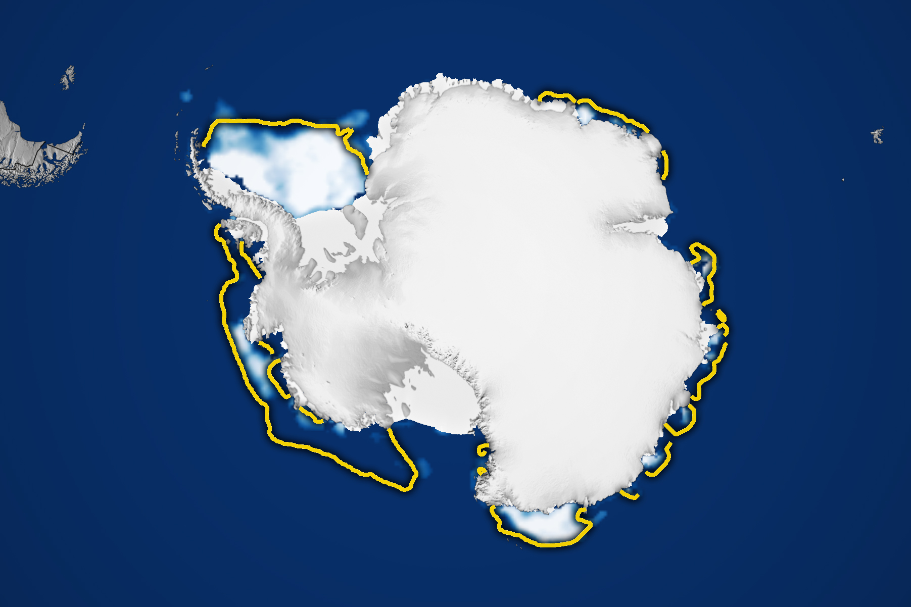
In 2025, summer ice in the Antarctic retreated to 764,000 square miles (1.98 million square kilometers) on March 1, tying for the second lowest minimum extent ever recorded. That’s 30% below the 1.10 million square miles (2.84 million square kilometers) that was typical in the Antarctic prior to 2010. Sea ice extent is defined as the total area of the ocean with at least 15% ice concentration.
The reduction in ice in both polar regions has led to another milestone — the total amount of sea ice on the planet reached an all-time low. Globally, ice coverage in mid-February of this year declined by more than a million square miles (2.5 million square kilometers) from the average before 2010. Altogether, Earth is missing an area of sea ice large enough to cover the entire continental United States east of the Mississippi.
“We’re going to come into this next summer season with less ice to begin with,” said Linette Boisvert, an ice scientist at NASA’s Goddard Space Flight Center in Greenbelt, Maryland. “It doesn’t bode well for the future.”
Scientists primarily rely on satellites in the Defense Meteorological Satellite Program, which measure Earth’s radiation in the microwave range. This natural radiation is different for open water and for sea ice — with ice cover standing out brightly in microwave-based satellite images. Microwave scanners can also penetrate through cloud cover, allowing for daily global observations. The DMSP data are augmented with historical sources, including data collected between 1978 and 1985 with the Nimbus-7 satellite that was jointly operated by NASA and the National Oceanic and Atmospheric Administration.
“It’s not yet clear whether the Southern Hemisphere has entered a new norm with perennially low ice or if the Antarctic is in a passing phase that will revert to prior levels in the years to come,” said Walt Meier, an ice scientist with NSIDC.
By James Riordon
NASA’s Earth Science News Team
Media contact: Elizabeth Vlock
NASA Headquarters
Share
Details
Related Terms
Explore More


What's Your Reaction?