


NASA Tests New Ways to Stick the Landing in Challenging Terrain
Advancing new hazard detection and precision landing technologies to help future space missions successfully achieve safe and soft landings is a critical area of space research and development, particularly for future crewed missions. To support this, NASA’s Space Technology Mission Directorate (STMD) is pursuing a regular cadence of flight testing on a variety of vehicles, […]

6 min read
Preparations for Next Moonwalk Simulations Underway (and Underwater)
Advancing new hazard detection and precision landing technologies to help future space missions successfully achieve safe and soft landings is a critical area of space research and development, particularly for future crewed missions. To support this, NASA’s Space Technology Mission Directorate (STMD) is pursuing a regular cadence of flight testing on a variety of vehicles, helping researchers rapidly advance these critical systems for missions to the Moon, Mars, and beyond.
“These flight tests directly address some of NASA’s highest-ranked technology needs, or shortfalls, ranging from advanced guidance algorithms and terrain-relative navigation to lidar-and optical-based hazard detection and mapping,” said Dr. John M. Carson III, STMD technical integration manager for precision landing and based at NASA’s Johnson Space Center in Houston.
Since the beginning of this year, STMD has supported flight testing of four precision landing and hazard detection technologies from many sectors, including NASA, universities, and commercial industry. These cutting-edge solutions have flown aboard a suborbital rocket system, a high-speed jet, a helicopter, and a rocket-powered lander testbed. That’s four precision landing technologies tested on four different flight vehicles in four months.
“By flight testing these technologies on Earth in spaceflight-relevant trajectories and velocities, we’re demonstrating their capabilities and validating them with real data for transitioning technologies from the lab into mission applications,” said Dr. Carson. “This work also signals to industry and other partners that these capabilities are ready to push beyond NASA and academia and into the next generation of Moon and Mars landers.”
The following NASA-supported flight tests took place between February and May:
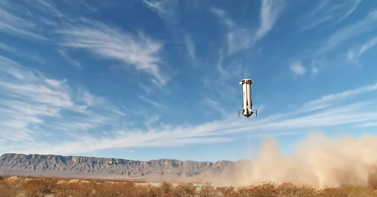
Suborbital Rocket Test of Vision-Based Navigation System
Identifying landmarks to calculate accurate navigation solutions is a key function of Draper’s Multi-Environment Navigator (DMEN), a vision-based navigation and hazard detection technology designed to improve safety and precision of lunar landings.
Aboard Blue Origin’s New Shepard reusable suborbital rocket system, DMEN collected real-world data and validated its algorithms to advance it for use during the delivery of three NASA payloads as part of NASA’s Commercial Lunar Payload Services (CLPS) initiative. On Feb. 4, DMEN performed the latest in a series of tests supported by NASA’s Flight Opportunities program, which is managed at NASA’s Armstrong Flight Research Center in Edwards, California.
During the February flight, which enabled testing at rocket speeds on ascent and descent, DMEN scanned the Earth below, identifying landmarks to calculate an accurate navigation solution. The technology achieved accuracy levels that helped Draper advance it for use in terrain-relative navigation, which is a key element of landing on other planets.
High-Speed Jet Tests of Lidar-Based Navigation
Several highly dynamic maneuvers and flight paths put Psionic’s Space Navigation Doppler Lidar (PSNDL) to the test while it collected navigation data at various altitudes, velocities, and orientations.
Psionic licensed NASA’s Navigation Doppler Lidar technology developed at Langley Research Center in Hampton, Virginia, and created its own miniaturized system with improved functionality and component redundancies, making it more rugged for spaceflight. In February, PSNDL along with a full navigation sensor suite was mounted aboard an F/A-18 Hornet aircraft and underwent flight testing at NASA Armstrong.
The aircraft followed a variety of flight paths over several days, including a large figure-eight loop and several highly dynamic maneuvers over Death Valley, California. During these flights, PSNDL collected navigation data relevant for lunar and Mars entry and descent.
The high-speed flight tests demonstrated the sensor’s accuracy and navigation precision in challenging conditions, helping prepare the technology to land robots and astronauts on the Moon and Mars. These recent tests complemented previous Flight Opportunities-supported testing aboard a lander testbed to advance earlier versions of their PSNDL prototypes.

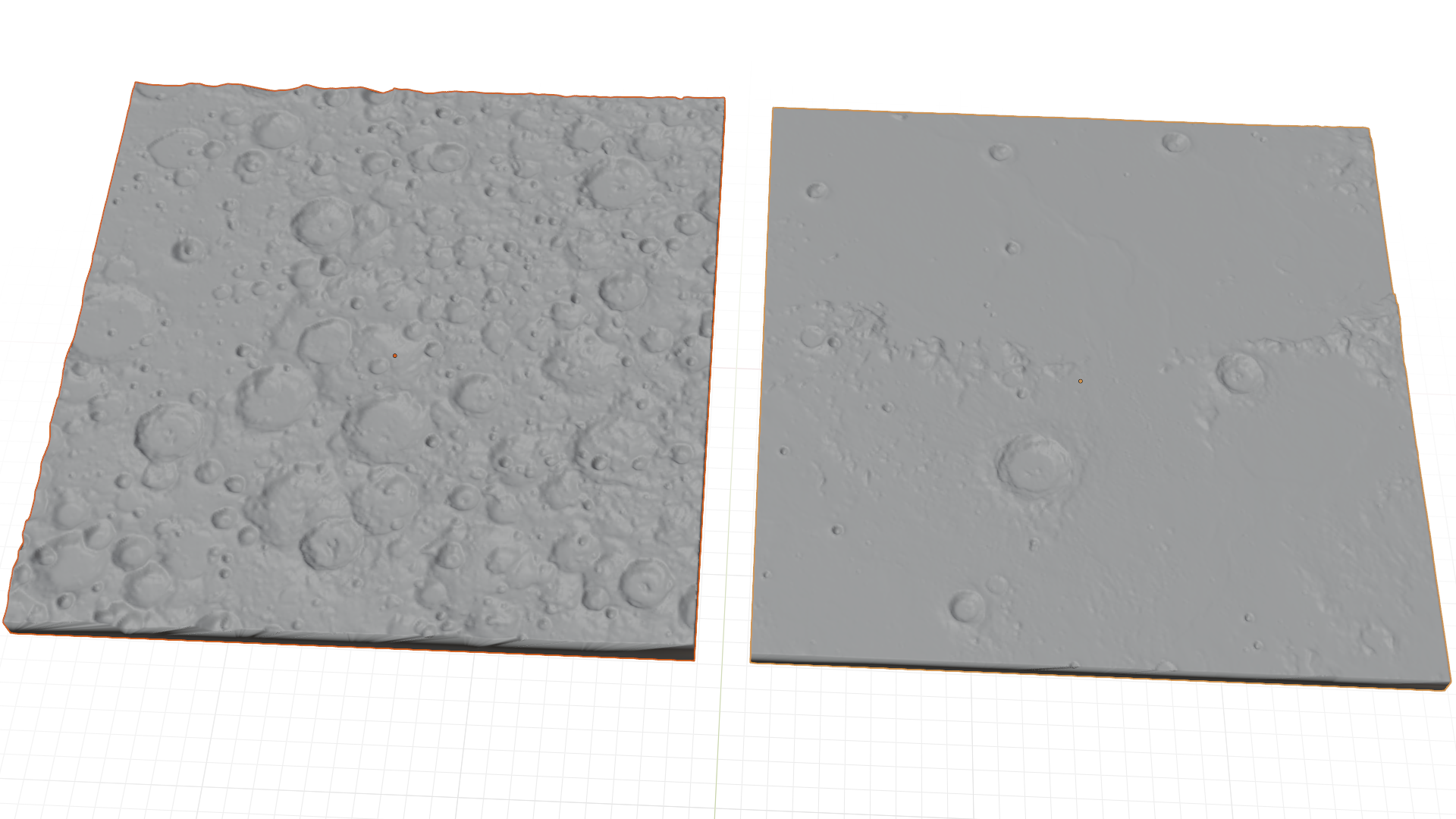
Helicopter Tests of Real-Time Mapping Lidar
Researchers at NASA’s Goddard Space Flight Center in Greenbelt, Maryland, developed a state-of-the-art Hazard Detection Lidar (HDL) sensor system to quickly map the surface from a vehicle descending at high speed to find safe landing sites in challenging locations, such as Europa (one of Jupiter’s moons), our own Moon, Mars, and other planetary bodies throughout the solar system. The HDL-scanning lidar generates three-dimensional digital elevation maps in real time, processing approximately 15 million laser measurements and mapping two football fields’ worth of terrain in only two seconds.
In mid-March, researchers tested the HDL from a helicopter at NASA’s Kennedy Space Center in Florida, with flights over a lunar-like test field with rocks and craters. The HDL collected numerous scans from several different altitudes and view angles to simulate a range of landing scenarios, generating real-time maps. Preliminary reviews of the data show excellent performance of the HDL system.
The HDL is a component of NASA’s Safe and Precise Landing – Integrated Capabilities Evolution (SPLICE) technology suite. The SPLICE descent and landing system integrates multiple component technologies, such as avionics, sensors, and algorithms, to enable landing in hard-to-reach areas of high scientific interest. The HDL team is also continuing to test and further improve the sensor for future flight opportunities and commercial applications.

Lander Tests of Powered-Descent Guidance Software
Providing pinpoint landing guidance capability with minimum propellant usage, the San Diego State University (SDSU) powered-descent guidance algorithms seek to improve autonomous spacecraft precision landing and hazard avoidance. During a series of flight tests in April and May, supported by NASA’s Flight Opportunities program, the university’s software was integrated into Astrobotic’s Xodiac suborbital rocket-powered lander via hardware developed by Falcon ExoDynamics as part of NASA TechLeap Prize’s Nighttime Precision Landing Challenge.
The SDSU algorithms aim to improve landing capabilities by expanding the flexibility and trajectory-shaping ability and enhancing the propellant efficiency of powered-descent guidance systems. They have the potential for infusion into human and robotic missions to the Moon as well as high-mass Mars missions.
By advancing these and other important navigation, precision landing, and hazard detection technologies with frequent flight tests, NASA’s Space Technology Mission Directorate is prioritizing safe and successful touchdowns in challenging planetary environments for future space missions.
Learn more: https://www.nasa.gov/space-technology-mission-directorate/
By: Lee Ann Obringer
NASA’s Flight Opportunities program
Explore More


Share
Details
Related Terms
What's Your Reaction?